Geographic Location
Wao is strategically located at the heart (center) of Mindanao. It is a landlocked municipality on the southeastern portion of Lanao del Sur Province. It is bounded on the north by the Municipality of Bumbaran in Lanao del Sur Province; on the south by the Municipality of Banisilan in Cotabato Province; and on the east by the Municipalities of Kalilangan and Pangantucan in Bukidnon Province. Wao lies approximately at a geographic coordinate of North Latitude 7⁰38’18’’ and East Longitude 124⁰43’24’’.
Municipal Land Area by Barangay and Boundaries
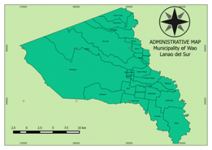
Wao is one of the 39 municipalities in the province of Lanao del Sur of the Autonomous Region in Muslim Mindanao. It is composed of 26 Barangays with a total land area of 36,388.2919 hectares. It is about three (3) percent of the total land area (1,206,182 has.) of Lanao del Sur Province. At present, the development of urban form in the municipality is concentrated in four (4) barangays of Eastern, Western, Extension and Manila Group. These 4 urban barangays have an aggregate total land area of about 230 hectares that serves a center of trade and commerce and administrative services. It is also where infrastructure support facilities are concentrated. Based on National Coordinating and Statistics Board (NCSB) data, there are two (2) barangays i.e. Pagalongan and West Kili-Kili that can be classified as urbanizing barangays with a total land area of 34,668.33 hectares which constitute about 93.38% of the total land area of the municipality.

[1] Area calculation derived from CLUP updating data and the initial data from Cadastral Survey where the total land area presented are data calculated from all thematic, derived and composite maps which form part and basis of the plan. These maps are validated through ground truthing using Global Position System (GPS) and GIS calculated area (ca.).
data source: MPDC Municipal Profile